The best 70-year-old map of Shanghai
 BEST OF SHANGHAI: ‘One man’s opinion’
I’ll keep this short, because I know that, like me, you are all probably rushing around doing your last-minute Chinese New Year shopping. Wait a minute — this thing I’m writing about would actually be a perfect gift. I mean, what is better to hand out on the most important of Chinese holidays than a historic Shanghai map from a time when most of the city’s streets had French names? Better yet, what if that map was created by an American who helped establish the Nationalist government?
I know what you’re thinking: Dan, this actually sounds like a much better gift for Valentine’s Day. And — you know what? — you’re right. What says I love you better than an old map? “Baby, I was lost until I found you …” — the card really writes itself! This map would never fit in one of those Spring Festival red envelopes anyway.
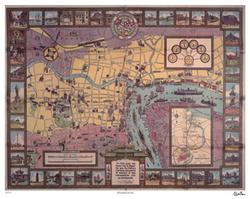
Failed attempts at humor aside, this 70-year-old map — brought back to life in limited edition form by longtime Shanghai resident and author Paul French — would be a great gift, during any time of year, for a Shanghai history buff or any resident of Shanghai. It also may dispel some longstanding urban myths about that “former swamp” we know as Pudong.
“The Municipal Council’s map, issued for visitors to Shanghai in 1935, shows a city that had grown up in the previous 20 years — by 1935 the Bund was formed pretty much as we know it today and the International Concession reached out past the race course, now People’s Square,” French said. “One interesting thing to note is that when supposed old hands in Shanghai tell you Pudong was nothing but fields and farms when they came here you’ll know they are bullshitting — the map shows how Pudong was a thriving factory area then around what is now Lujiazui.”
French stumbled upon the map while doing research on Carl Crow, an old China hand from America, and the subject of French’s current book project.
“Carl Crow was virtually a household name between the wars in the U.S. and many other countries,” French said. “He was an incredible number of people’s first introduction to China and I meet people all the time who tell me how influenced they were by his books. Most of us are lucky if we get to live one semi-interesting life — Crow, as a journalist, advertising man, and traveler got to live several fascinating lives.”
For details about Crow, the map and how you can get one, I’m going to be lazy and just quote the materials Paul sent me. Forgive me, I just finished writing a 50-page book proposal. And, frankly, I’d rather be at the beach right now.
This should cover most of your questions:
In 1935, the Shanghai Municipal Council issued a map for visitors to the city. The man they hired to produce it was an American called Carl Crow. The map was a spectacular success and instantly became a collector’s item and is now extremely rare. For this reason we have decided to reproduce the map in a full color, limited edition.Crow arrived in Shanghai in 1911 establishing the China Press newspaper. The city was his home for the next 25 years as he worked as a journalist, adman, hostage negotiator, police sergeant, farmer and propagandist. He became a best-selling author, known for his wry, observant and sympathetic portraits of life in Shanghai. Arriving as the Qing Dynasty was collapsing and leaving as the city was being bombed in 1937, he left behind an enduring written legacy of Shanghai between the wars … and this map.
All proceeds from the map will go towards reproducing Crow’s entire archive (currently held at the University of Missouri) of unpublished work, diaries and correspondence and storing it in Shanghai for use by future generations of researchers into the city’s history.
Each map is 20” X 25” (50.8 cm X 63.5 cm), full color and with a copy of Carl Crow’s signature added. Additionally each map is stamped on the reverse as a limited edition, numbered and accompanied with details of the origins of the map, Crow and V.V. Kovalsky, the cartographer.
Maps are available by collection in Shanghai or by post at the following rates:
Currency: Poster, P&P
RMB: 250, 300
HK$: 235, 282
US$: 30, 36
UK: 16, 19For more details contact Paul French on +86-21-6374-5679 or paul @ accessasia.co.uk.
More about the map and Carl Crow:
This illustrated full colour map of the city’s International Settlement was commissioned by the Shanghai Municipal Council (SMC) in 1935 to be provided to visitors to the city as a tourist guide. Carl Crow was hired to oversee the project and used local artist VV Kovalsky to draw the map. Crow added the sidebar comments on the “history, customs and points of interest in this cosmopolitan city of Shanghai.”Carl Crow (1883-1945) was originally from Missouri and moved to Shanghai in 1911 to help found the English language China Press newspaper. Over the next few years he covered the collapse of the Qing Dynasty, the development of Shanghai and the establishment of the Nationalist government. He worked briefly in Tokyo before returning to Shanghai to found the famous Carl Crow Inc., an advertising agency.
Crow was a prolific journalist and writer for publications such as Liberty, The Saturday Evening Post, Pearson’s, McClure’s and the Reader’s Digest. His best selling books included the Handbook for China (that ran through 13 editions between the wars), his series of anecdotes of business life in inter-war China, 400 Million Customers and a portrait of the foreign communities of the China coast, Foreign Devils in the Flowery Kingdom.
After being evacuated from Shanghai in 1937 following the Japanese invasion of the city, Crow returned to America. However, he was soon back in war-torn China travelling up the Burma Road from Rangoon to Chongqing. Crow died in 1945 in New York City. During his quarter of a century in China Crow interviewed and grew to know most of the major characters in the country’s history including Sun Yat-sen, Chiang Kai-shek, Madam Chiang and Zhou En-lai.
VV Kovalsky was a White Russian emigre artist and cartographer who freelanced for various newspapers, periodicals and advertising agencies in Shanghai between the wars.
Paul French is a director at Access Asia, a Shanghai-based market research and business intelligence company specializing in China and North Asia economics and markets. He is currently writing a book about Carl Crow. French’s latest book, North Korea: The Paranoid Peninsula — A Modern History, came out earlier this year.
More about maps: For a cool — and current — interactive map of Shanghai, head on over to SmartShanghai.com. And for an acoustic mp3 of the Yeah Yeah Yeahs singing their song “Maps,” click here.
01.30.2005, 6:00 PM · Best of Shanghai
9 Comments
I think it is that “Paul French” guy was “bullshitting”, I am just using his words. Pudong was almost nothing but fields back to say 20 years ago. Yes, there were some factories along the Huanghu River. Five mins walk is all you need to reach a rice field after steps off from any ferry terminal.
Ummm…whatever Fact-i-boy, you don’t seem to know your ass from a hole in the ground. Do you even know where Shanghai is? Go stuff your mouth with Xiao Long Bao so we don’t have to listen to your crap anymore.
Whoa, Todd, from where did that diatribe arise? Was that necessary? What was Fact even saying? Do you think he knows what he was saying and what he had read? It seems not. But your violent attack hardly seems justified or appropriate.
Have a great Spring Festival, eh?
Don’t understand what got your so angry… It seems that a hole in the ground is all you need to stuck your head into and point your ass to the sky so everyone can see the ugly side of you.
Of course much of Pudong was farmland - and still is. However, those that tell you they stood on the Bund and gazed across at farms must be about 115 years old. Perhaps you might want to buy a copy of the excellent new collection of photographs put together by Xu Xixian and Xu Jianrong called A Changing Shanghai and published by the Shanghai People’s Fine Arts Publishing House - the book includes photographs of Shanghai taken in the 1970s and 1980s and then the same shots taken in the last couple of years. The contrast is of course startling - however if you can see any farmland from the Bund side across the river then you have better eyesight than me and more focus than the photographers lens. You will also see many photos of Pudong inland that show that much of the area was built up despite persistent claims that it was all paddy fields and chicken farms.
The strip along the HuangPu river was already built up with warehouses and shipyards, among other structures. Yes, it is not possible to see farmland from the Bund. But the farmland is not far away - a five mins walk from the river bank would do….
I suggest you dont mess with Tall Paul (French) if you dont want to end up in a North Korean reeducation labour camp.
Buy his very interesting book on North Korea and you’ll know what I mean.
It could be arranged
Interesting, I just found this link while looking for links to my site off of Yahoo via link:http://www.bloggedy.com/. Seems there was a spoof of me above. Do you have the logged IP address?
Anyway, the map looks really cool. Was a very different city back then. It’s also interesting to note also that in the early part of the last century, Shanghai was considered “domestic” for the U.S. postal service - it was just as expensive/cheap to mail things to Shanghai as inside of the continental U.S. The pre-liberation history of Shanghai is very interesting.
Next time I’m in Shanghai I’ll see about getting a map.